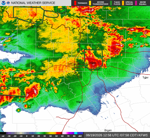
Immediate Flood Threat
A severe Flash Flood Warning is currently active for Frisco, TX, requiring immediate attention. This alert, issued by the National Weather Service in Fort Worth, remains in effect until 10:45 AM CDT today. Alongside this warning, a minor Flood Advisory is also active until 10:30 AM CDT. Conditions on the ground reflect this urgency, with heavy thunderstorms and heavy rain currently impacting the area. The air is saturated, with relative humidity at 100% and a dew point of 72F. Winds are blowing at 8 mph with gusts reaching 28 mph.
Today and Tonight Forecast
Today, the chance of showers and thunderstorms is high at 72%. The National Weather Service indicates a chance of these storms before 7 AM, followed by likely showers and thunderstorms between 7 AM and 1 PM, and a chance of them later. The sky will remain mostly cloudy. The high will reach near 87F, though temperatures may fall to around 85F in the afternoon. East winds will hover around 10 mph. Rainfall totals between three quarters and one inch are possible.
Tonight, conditions will remain mostly cloudy with a chance of showers and thunderstorms. The low will be near 74F, with temperatures rising to around 76F overnight. East southeast winds will range from 5 to 10 mph. The chance of precipitation drops to 30%, with new rainfall amounts between a quarter and half of an inch possible.
Tomorrow Outlook
Tomorrow, the weather will shift toward warmer and drier conditions, though rain remains possible. The high will climb to near 91F, with temperatures falling to around 89F in the afternoon. The sky will be mostly sunny. The heat index will reach as high as 102. South southeast winds will be 5 to 10 mph. The chance of precipitation is 40%, with rainfall amounts between a quarter and half of an inch possible.
Tomorrow night, skies will clear to mostly clear with a low around 77F. The heat index will remain high at 102. South winds will increase to 10 to 15 mph, with gusts up to 25 mph. The chance of precipitation is 30%, with less than a tenth of an inch of rain expected.


