Back to Weather

5-day forecast / Frisco, TX

TodayChance Showers And Thunderstorms91° / 79° 28%
SaturdayMostly Sunny94° / 78° 4%
SundayShowers And Thunderstorms88° / 68° 81%
MondayShowers And Thunderstorms80° / 65° 75%
TuesdayMostly Sunny87° / 73° 5%

Frisco Heat Index Hits 100 Today Amid Humid Showers

Frisco weather, refreshed every four hours — local forecasts you can plan your day around.

Frisco faces oppressive heat with a heat index near 100 today. Showers and thunderstorms are likely before 1pm, followed by a chance of storms in the afternoon. Temperatures will rise further tomorrow.

Camille Rourke

June 12, 20262 min read

National Weather Service radar for North Texas (KFWS)

Current Conditions and Heat Stress

It is currently Friday this afternoon in Frisco, TX, where the air temperature stands at 86F. However, the combination of heat and moisture makes it feel significantly hotter, with a feels-like temperature of 95F. The relative humidity is at 70%, and the dew point is 75F, indicating oppressively humid conditions. Winds are blowing at 6 mph with gusts reaching 15 mph, while the sky remains mostly cloudy.

Today's Forecast: Storms and High Heat

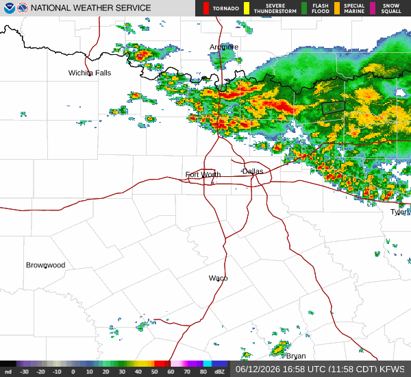
The National Weather Service indicates that showers and thunderstorms are likely before 1pm. Following this initial period, there is a chance of showers and thunderstorms between 1pm and 4pm. The sky will be partly sunny. The high today will be near 91F, with temperatures falling to around 86 in the afternoon. The heat index values are expected to reach as high as 100. South southeast winds will range from 5 to 10 mph. There is a 60% chance of precipitation, with new rainfall amounts between a tenth and quarter of an inch possible. Tonight will be partly cloudy with a low around 79F. The heat index will remain high at 100, with south southeast winds around 10 mph.

Tomorrow: Clearing Skies and Rising Temperatures

Conditions will shift tomorrow with mostly sunny skies. The high will reach near 95F, making it even hotter than today. The heat index values are forecast to climb to as high as 104. South winds will increase to 10 to 15 mph, with gusts as high as 25 mph. The chance of precipitation drops to 4%. Tomorrow night will see a slight chance of rain showers between 1am and 4am, followed by a slight chance of showers and thunderstorms. The sky will be mostly clear with a low around 78F, though temperatures may rise to around 80 overnight. The heat index will be as high as 101, with south winds of 10 to 15 mph. There is a 20% chance of precipitation, with less than a tenth of an inch of rain possible.

Safety Reminder

Given the high heat index values reaching 100 today and 104 tomorrow, it is crucial to stay hydrated and limit midday exertion. Check on neighbors and elderly relatives who may be vulnerable to extreme heat. While there are no active weather alerts, the humid conditions and potential for storms require caution.

National Weather Service radar for North Texas (KFWS)

Sources

https://radar.weather.gov

https://api.weather.gov

https://open-meteo.com

Share

Camille Rourke

Camille Rourke covers community life, events, and neighborhood features around Frisco.

Related Stories